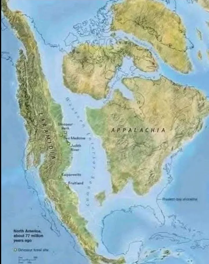
Imagine North America not as the sprawling, unified continent we know today, but as two distinct landmasses, separated by a vast, shallow sea. This wasn’t a fleeting moment; for millions of years, around 77 million years ago during the Late Cretaceous period, this was the reality. Get ready to dive into a prehistoric world vastly different from our own, a time of epic geological shifts, unique ecosystems, and some of the most famous dinosaurs to ever roam the Earth.
The Western Interior Seaway: America’s Ancient Heart
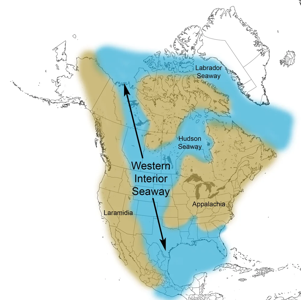
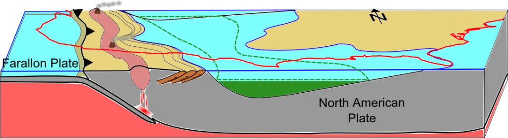
The star of this ancient drama was the Western Interior Seaway. This colossal inland sea stretched from what is now the Gulf of Mexico all the way to the Arctic Ocean, effectively cleaving North America down its middle. Picture a waterway so immense it dwarfed any modern-day strait or channel, transforming the continent into an archipelago of sorts.
The seaway wasn’t just a watery divide; it was a vibrant, thriving marine ecosystem. Its warm, sunlit waters teemed with life. Imagine colossal mosasaurs, often likened to the T-Rex of the seas, patrolling its depths, alongside long-necked plesiosaurs and the fascinating shelled cephalopods known as ammonites. Their fossilised remains, found far from today’s coastlines across the central United States and Canada, are a testament to this incredible ancient sea.
Laramidia and Appalachia: Two Worlds Apart
The presence of the Western Interior Seaway created two distinct landmasses:
- Laramidia to the West: This was a long, narrow strip of land running along what would become the Rocky Mountains. If you’re a dinosaur enthusiast, Laramidia is where much of the action happened! Its varied landscapes, from volcanic highlands to lush river deltas, fostered an incredible diversity of dinosaur life. This was the stomping ground for legends like the fearsome Tyrannosaurus rex, the three-horned Triceratops, and a vast array of duck-billed hadrosaurs – the grazing giants of their time. The rich fossil beds of places like Alberta, Montana, and Wyoming are all part of Laramidia’s enduring legacy.
- Appalachia to the East: Separated by the vast seaway, Appalachia was a distinct world. While its fossil record isn’t as extensively studied as Laramidia’s, we know it was characterised by dense forests, extensive swamps, and evolving flowering plants. Its dinosaurs, though perhaps less famous, were unique, having evolved in isolation from their western cousins. The geological history and fossil discoveries from Appalachia offer intriguing glimpses into a different side of Late Cretaceous North America.
A Warmer World: The Greenhouse Earth
What allowed such a massive inland sea to exist? The answer lies in the global climate of the Late Cretaceous. This was a “greenhouse Earth” – a period of sustained warmth with no polar ice caps. This meant significantly higher global sea levels, providing the conditions necessary for the Western Interior Seaway to form and persist for millions of years.
The warmer climate also fostered incredibly lush and verdant environments across both Laramidia and Appalachia. Imagine dense, subtropical forests teeming with life, providing ample food and shelter for the prehistoric giants that roamed these ancient lands.
Ancient Life of the Western Interior Seaway
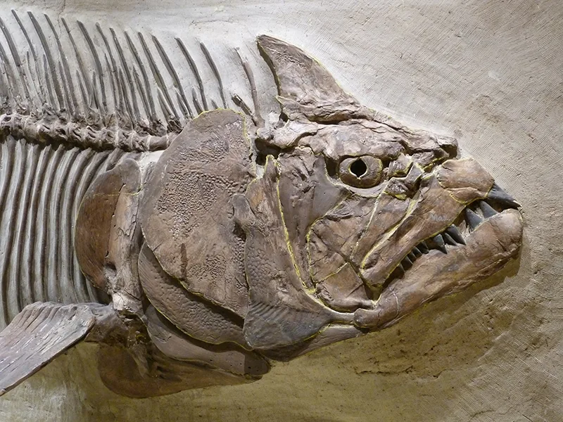
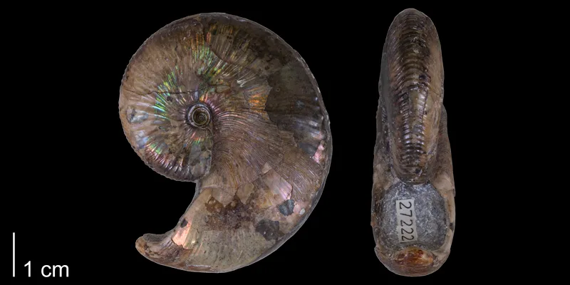
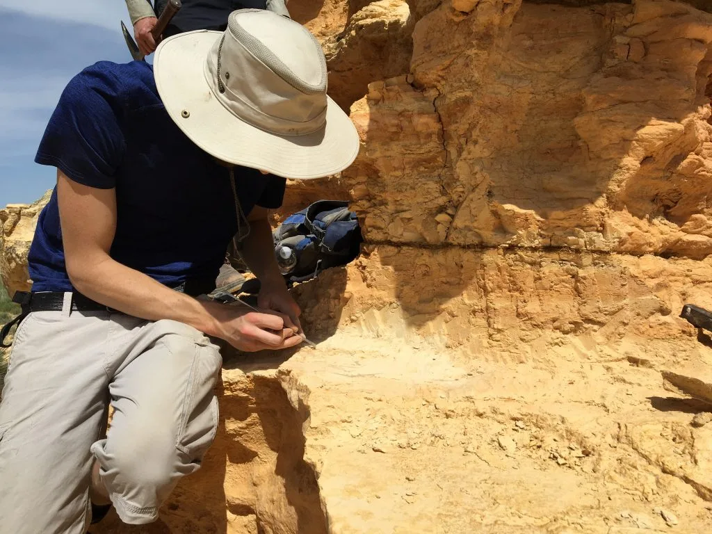
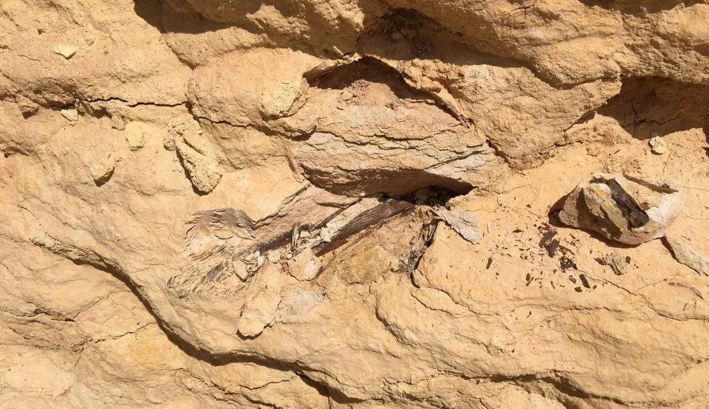
The waters of the WIS were warm, shallow, and inhabited by a plethora of marine animals. These included bony fish (including the monstrous Xiphactinus, or X-fish), sharks, marine reptiles such as mosasaurs and plesiosaurs, birds, mollusks (including ammonites, bivalves, and snails), and echinoderms (including echinoids and crinoids). Winged pterosaurs also flew overhead. Conditions on the WIS ocean floor were periodically anoxic (with little or no oxygen). Because of this, dead animals that sank to the bottom of the WIS often decomposed slowly, favoring their preservation as fossils.
Why Does It Matter Today?
Understanding this ancient configuration of North America isn’t just a fascinating historical curiosity. It’s crucial for paleontologists and geologists. The separation of Laramidia and Appalachia led to distinct evolutionary pathways for dinosaurs on either side, resulting in unique species. The fossil record of the Western Interior Seaway provides invaluable data on marine life and ancient ocean conditions.
So, the next time you look at a map of North America, take a moment to imagine it divided, teeming with ancient life, and ruled by a vast, shimmering inland sea. It’s a powerful reminder of how dramatically our planet has changed, and the incredible stories held within its ancient rocks.
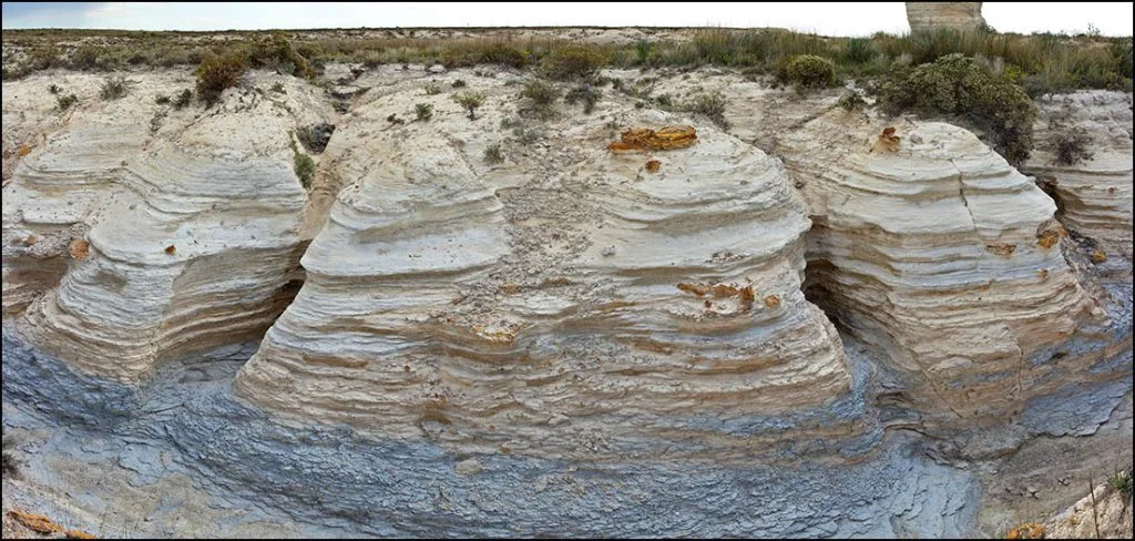
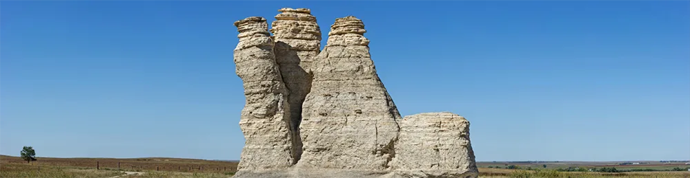
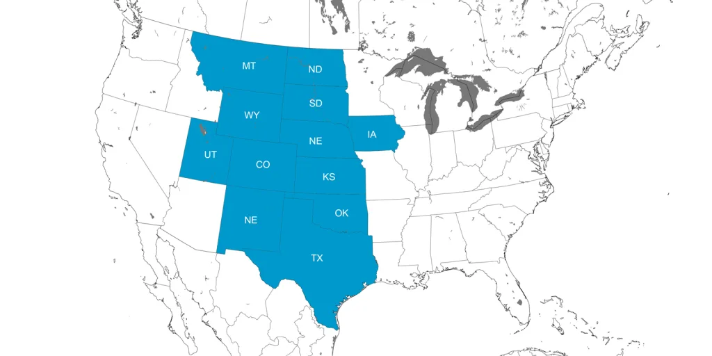
Traces of the Western Interior Seaway can still be found in marine deposits throughout the United States ranging from New Mexico to North Dakota, including famous ones such as the Pierre Shale and the Austin Chalk. Some of the most notable outcrops are the Monument Rocks of Western Kansas, that are comprised of the Smokey Hills Chalk of the larger Niobrara Formation.
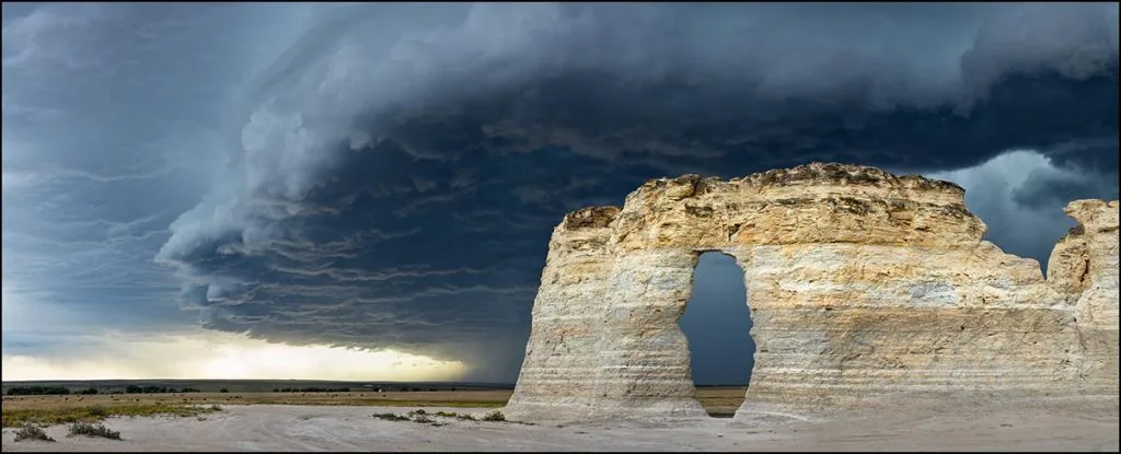
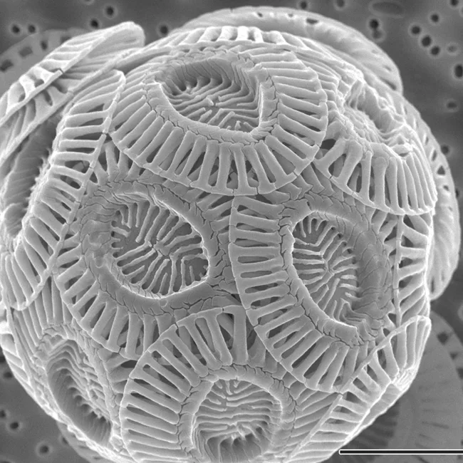
Coccolithophores lived in the water column during life, but sank to bottom of the sea upon death, forming large accumulations of chalk over millions of years. The chalk layers visible at Monument Rocks are the erosional remnants of a much larger outcrop belt that was scoured away by the Smoky Hill River several thousand years ago.
Sometimes called the “Chalk Pyramids,” Monument Rocks is a US Department of Interior National Natural Landmark. (Click on the image below to access a highly detailed GigaPan image of Monument Rocks that was produced by Richard T. Bryant).
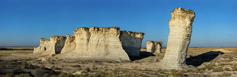
Many of the incredible paleontological discoveries made by the famous Sternberg fossil collecting family in the late 19th and early 20th centuries, including mosasaurs, pterosaurs, and fossil fish, were made near Monument Rocks. These are today on display at natural history museums throughout the world.
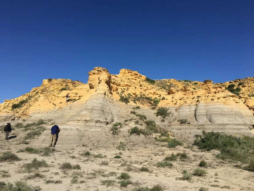
Another famous outcrop of the Smoky Hills Chalk occurs a bit east of Monument Rocks and is known as Castle Rock. This was an important landmark on the Overland Trail, an alternative to the Oregon and California Trails, that led through the American West. (Click on the image below to access a GigaPan photograph of Castle Rock.)
Ages of Western Interior Seaway Deposits
Marine rocks from the end of the Early Cretaceous and the much of the Late Cretaceous are well represented states in states once covered by the WIS.
The tables below provide the geologic stages of the major fossil-bearing stratigraphic units in each of these states. The ages of these stages are:
Late Cretaceous:
- Maastrichtian: 72.1-66.0 Ma.
- Campanian: 83.6-72.1 Ma.
- Santonian: 86.3-83.6 Ma.
- Coniacian: 89.9-86.3 Ma.
- Turonian: 93.9-89.9 Ma.
- Cenomanian: 100.5-93.9 Ma.
Early Cretaceous:
- Albian: 113.0-100.5 Ma
Note: Ma = millions of years ago.
Abbreviations: Chk = Chalk; Fm = Formation; Grp = Group; Lmst = Limestone; Sh = shale; SS = sandstone.
What do you find most fascinating about this ancient North American landscape? Share your thoughts in the comments below!
Source: cretaceousatlas.org