A Journey from the Rockies to the Gulf
Geology on Display
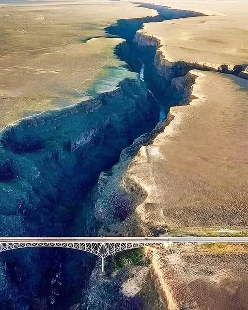
The River: Río Grande / Río Bravo
Let’s start with the star of the show: the Rio Grande.
| Fact | Detail |
|---|---|
| Length | ~1,896 miles (3,051 km) |
| Rank | 4th-longest river in North America |
| Source | San Juan Mountains, Colorado (Continental Divide) |
| Mouth | Gulf of Mexico (near Brownsville, TX) |
| Name Origin | Río Grande = “Big River” (Spanish); Río Bravo = “Wild River” (Mexico) |
This isn’t just any river. It’s a geological sculptor, a political boundary (Texas–Mexico), and a lifeline for millions across three U.S. states and five Mexican states.
But its most jaw-dropping work? Right here in New Mexico.
The Geology: Lava, Rift, and Relentless Erosion
The story begins 5 million years ago, during the Pliocene epoch.
1. The Taos Plateau Volcanic Field
- Part of the larger Rio Grande Rift — a tectonic tear in the Earth’s crust stretching from Colorado to Mexico.
- Basalt lava flows erupted repeatedly, creating a 1,000-foot-thick cap of dark volcanic rock across the plateau.
- These flows are Servilleta Basalt, dated 3.6–4.5 million years old.
2. The Rift Opens
- The Earth’s crust began pulling apart (extension), forming a graben (sunken block).
- The Rio Grande followed this weakness, flowing south through the rift valley.
3. The River Starts Cutting
- Initially, the river flowed on top of the basalt.
- Over time, downcutting began — the river eroded downward into the lava cap.
- Rate: About 1 foot every 2,000 years (slow, but relentless).
Result: A steep-walled gorge with near-vertical cliffs of layered basalt — some flows up to 100 feet thick.
Anatomy of the Gorge
| Feature | Description |
|---|---|
| Depth | Up to 800 ft (244 m) |
| Width | 500–1,000 ft at rim; narrows to ~50 ft at river level |
| Length | ~50 miles (80 km) from Colorado border to below Taos Junction Bridge |
| Rock Layers | 3–7 distinct Servilleta Basalt flows, separated by paleosols (ancient soils) |
| Inner Gorge | A narrower slot carved into older Precambrian rocks (1.7 billion years old) |
Pro tip: Look for columnar jointing in the basalt — hexagonal columns formed as lava cooled and contracted. It’s like nature’s own Stonehenge.
The Bridge: An Engineering Icon
The Rio Grande Gorge Bridge (completed 1965) is more than a roadway — it’s a landmark.
| Stat | Value |
|---|---|
| Height above river | 650 ft (198 m) |
| Rank in U.S. | 10th-highest bridge |
| Length | 1,280 ft (390 m) |
| Design | Steel deck arch |
| Nickname | “The High Bridge” |
- Won the American Institute of Steel Construction’s “Most Beautiful Long-Span Bridge” award in 1966.
- Featured in films: Terminator Salvation, Natural Born Killers, Wild Hogs.
- Suicide prevention: Fences and crisis phones added in 2010s.
Stand in the middle. Feel the wind roar up the canyon. Look down. The river looks like a garden hose.
Ecology: Life in the Vertical Desert
Despite the harshness, the gorge teems with life.
Wildlife
- Golden eagles and peregrine falcons nest on cliffs.
- Bighorn sheep (reintroduced in 1990s) scale impossible ledges.
- River otters (yes, otters!) thrive in the Rio Grande.
- Black bears and mountain lions roam the rim.
Plants
- Riparian zone: Cottonwoods, willows, coyote willow.
- Upland: Piñon-juniper woodland, sagebrush, prickly pear.
- Cliff faces: Lichens, mosses, and rare hanging gardens fed by seeps.
Human History: 12,000 Years of Footprints
| Era | People & Culture |
|---|---|
| 12,000 BCE | Paleo-Indians hunt mammoths near the river. |
| 900–1300 CE | Ancestral Puebloans build pit houses and farm maize on the plateau. |
| 1500s | Spanish explorers name the river Río Bravo. |
| 1800s | Taos Pueblo (1,000+ years old) maintains spiritual ties to the gorge. |
| 1960s | Hippie communes settle nearby (e.g., New Buffalo). |
Things to Do: Adventure Awaits
1. Walk the Bridge
- Free parking on both sides.
- Pedestrian walkway with stunning views.
2. Hike the Rim
- West Rim Trail (9 miles, easy-moderate): Panoramic views, wildflowers, petroglyphs.
- Rift Valley Trail (to the river): Steep 800-ft descent — bring water!
3. Raft the River
- Taos Box (Class IV rapids): 17-mile whitewater run through the deepest part of the gorge.
- Racecourse (Class III): Family-friendly half-day trip.
4. Camp
- Orilla Verde Recreation Area (BLM): Riverside sites with picnic tables.
- Wild Rivers Backcountry: Primitive camping with solitude.
Best Times & Tips
| Season | Pros | Cons |
|---|---|---|
| Spring (Apr–May) | Wildflowers, mild temps, high water | Muddy trails |
| Summer (Jun–Aug) | Long days, rafting peak | Hot (90°F+), monsoon storms |
| Fall (Sep–Oct) | Golden cottonwoods, crisp air | Crowds on weekends |
| Winter | Snow-dusted rims, solitude | Icy trails, cold river |
A Final Look Down
The Rio Grande Gorge isn’t just a hole in the ground. It’s a 5-million-year collaboration between:
- Volcanic fire (that built the plateau)
- Tectonic stretch (that cracked it open)
- Water’s whisper (that carved it deep)
Stand at the edge. Watch a raven ride an updraft. Listen to the river — still cutting, still shaping, still telling its story.
Because here, in this black canyon under a vast sky, you’re not just a visitor.
You’re a witness.
📍 Location: 10 miles west of Taos, NM via US-64 🅿️ Parking: Free at Rio Grande Gorge Bridge Rest Area 🎟️ Entry: Free (BLM land) 🐶 Dogs: Allowed on leash