(A repost, originally written by Carl, November 13, 2013. The post has been expanded from the original.)
Tomorrow, the fourteenth of November, will be the official birthday of Surtsey. In a way it was a triple birth. First of all it was the birth of the Island of Surtsey, it was also the birth of the term surtseyan eruption, but foremost it was in a way the birth of the modern world and the age of television.
Never before had the world’s population been able to watch proof that the world was a changing place born in fire and baptized in ice cold waters in a remote part of the world while staying at home, in one go it made a huge amount of people aware of plate tectonics, and the budding science of volcanology.
It was an archetypical moment for the television medium, one could say that the birth of television started with Surtsey and ended 6 years later with the moon landing. Both are epic moments from a time when we dared dream on a scale we will not see again as we move further into a Digital Dark Age of Introversy* and cat-images on Facebook.
At the same time Surtsey heralded the birth of modern volcanology and that is why Surtsey gave its name to underwater eruptions that form islands. It was far from the first island forming eruption, but it was at the same time THE island formation, not only for the general population, it was also the defining moment for volcanology, which at the time was forming as an independent science. Remember that Surtsey happened a year before Ian Carmichaels ground breaking petrological work on the Icelandic volcano of Thingmuli.
At the same time surprisingly little is known about the eruption. Yes, there are television clips and news photographs, and endless reporting on the event. But, from a modern scientific view there is almost nothing. One should though remember that there was almost no seismographic data available since the Icelandic network was in its infancy. On top of that the scientists back then hardly even knew what to look for, there was not even a clear cut protocol for what to look for. To set it into proportion, the Hekla network yields more data per minute than was recorded during the entire eruption of Surtsey, but we should also remember that without Surtsey we would most likely not have the luxury of today’s public network that the Icelandic Met Office let us partake from on a daily basis. In the end, that is the legacy of Surtsey; that we can sit in our living rooms and ponder and debate volcanoes around the globe, most likely driving scores of professional volcanologist insane while doing it…
Geological background
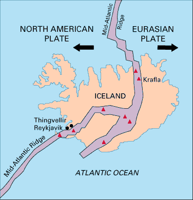
Up until roughly 12 000 years ago the EVZ stopped at a location close to Eyjafjallajökull. At that time the rift started to spread southwards and the Vestmannaeyjar islands was born. In time this opening faultline will take over the position entirely as the center for MAR-spread from the Reykjavik Ridge, but right now it is still in its formative stages.
All eruptions along this part of the EVZ are rifting eruptions, and no central volcanoes have yet formed, even though some argue that the Eldfell eruption on Heimaey heralded the formation of a proto central volcano, there is though no substantial evidence for that theory.
So far no volcano on the Vestmannaeyar Fissure Swarm has had a second eruption, a base requirement for a central volcano.
The Surtsey Eruption
On the sixth of November the villagers of Kirkjubæjarklaustur noticed the onset of a weak earthquake swarm and the local seismograph registered the direction and the rough distance. Later analysis has determined the origin to be roughly within the area of the Surtsey eruption. The earthquake swarm ended or became too weak to register on the eighth of November.
On the twelfth of November a seismograph in Reykjavik recorded a ten hour long period of what later has been interpreted as harmonic tremor. At the same time a hydrological research ship had measured water temperatures in the area above the established baseline. In the town of Vík, 80 kilometers away the locals noticed the rotten egg smell of hydrogen sulphide (H2S), something that they knew indicated volcanic activity somewhere.
From all of this we know that sometime between the 6th up to the 12th the Surtsey eruption started. Closer than that we will never come due to the lack of hard data.
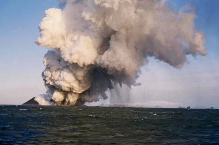
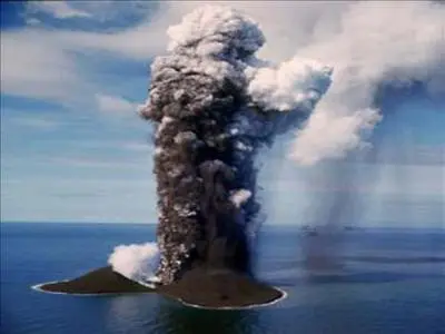
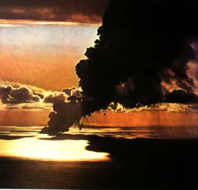
What we do know is that at 06.30 in the morning on the 14th of November 1963, the crew of the trawler Ísleifur II noticed a smell of sulfur in the air. Neither the cook nor the engine was to blame, and in the darkness the cause could not be found. At 07.30, the cook who had te look-out duty, saw a column of black smoke. The captain decided to go closer to investigate if it was a burning ship or if it was a volcanic eruption. As they got closer they saw that it was a column of ash, giving it away as a submarine eruption, which the captain reported to an astonished radio operator. The ship sailed as close as half a nautical mile to the eruption, but wisely retreated before the lava bombs began to rain down. The crew measured a sea temperature 2 degrees above normal. The next day, the cone broke the water surface and an island was born. Interesting, the sea now cooled down again, being insulated from the eruption by the pumice cone.
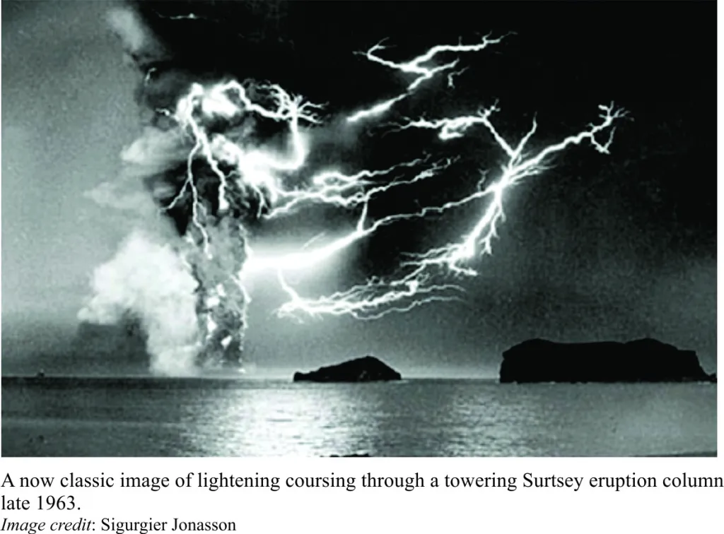
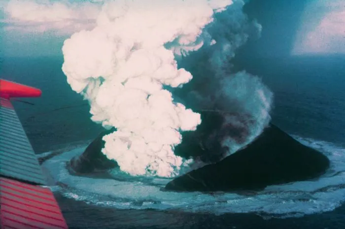
The eruption started at a depth of 130 meters, so we know that the eruption would initially not have been visible. During the first few days there were 3 distinct different eruptions along the NNE/SSW trending fissure line of the EVZ, but later in the day they formed into one single 10 kilometer high ash and steam column.
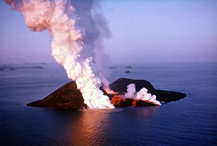
Over the next few days an island formed that was 500 meters long and 45 meters high. By November 20 it had reached 70 meters height. It was built by alternating layers of scoriae and ash and as such started to erode immediately – pumice began to float away, and the winter storms regularly broke through the crater walls. The sea would cover the magma, and the evaporating water formed continuous cauliflower clouds, occasionally even reaching the stratosphere, while ash fell like a dark rain. Airplanes reported long ash plumes – this was before the danger of ash to their engines was understood, and some of the trans-atlantic flight may have been operating in conditions which nowadays would be considered unsafe. When the sea entered the conduit, an explosion would follow with a mass of black tephra rushing up at speed of up to 100 m/s, and fanning out into plume-like jets looking like a puff of black feathers. But the eruption build the island faster than the sea could take it down. By February 1964, it had reached 174 meters height. The island had grown into such a size that the lava did not any longer interact with the water and the eruption therefore changed in nature. Now it was instead basaltic lava that was ejected in fire fountains and lava flows. This quickly covered the lose debris with a hardened shell, thusly saving the budding island from the waves. In February, the original crater stopped erupting and a new crater further west started up, called Surtur-II. Lava bombs were thrown as high as 2.5 km. From April 1964, the crater walls were water-proof and the eruption was now ‘dry’. This was the first time lave fountains formed, up to 100 meters tall. A lava lake formed, and lava flowed over the walls. Fast flows formed Pahoehoe lava (‘hellu’ in Iceland) and slow ones formed a’a lava (‘apal’).
This effusive phase of the eruption continued from the Surtsey vent up until 7 May 1965.
Legal issues
During the first eruption of Surtsey, 3 French journalists landed on the island for fifteen minutes before being driven away by the volcano. As a joke they claimed the island for France. According to international law that would have made the island French since the eruption happened outside of the Icelandic 3-mile maritime zone. Iceland quickly moved to assert its rights to the island, and France never acknowledged its legal right to the island making Surtsey de facto Icelandic. The claim is though disputable since there is no legal limit to the time for claiming new land.
This might sound like legal nitpickery, but let us say that a couple of enterprising Somali pirates claimed one of the two newly born islands in the Jebel al-Zubair group, that would give Somalia legal claim to all navigable water in the world’s most heavily trafficked waters. The Devil quite literally lives in the details and there have been small scale wars fought over ephemeral islands in the Mediterranean.
Surtla, Syrtlingur and Jólnir
On the 28th of December of 1963 a second fissure eruption started 2.5 kilometers to the north east of Surtsey creating a 100 meter high seamount, it never reached the surface, but the eruption was still named Surtla since it was expected to break the surface.
At the same time as the first eruption on Surtsey dwindled down into an intermission a new fissure opened up 0.6 kilometers southwest of Surtsey. This eruption formed the island of Syrtlingur on the 28th of May 1965, the island quickly eroded and disappeared under the surface, and it then reappeared again on the 14th of June. In the beginning of October the same year this eruption ended and on the 24th of October the island was washed away by the waves to never appear again.
In December 1965 yet another eruption started 0.9 kilometers southwest of Surtsey. This weak eruption fought for 8 months to stay above the ocean surface until the eruption ended on the 8th of August 1966 and in October the waves had eroded away the 70 meter high island of Jólnir.
Second Surtsey eruption
On the 19th of August 1966, a 200-meter long fissure formed cutting through the original Surtur crater. Lava started flowing at Surtsey again, at one point threatening the hut erected for the scientists. This second layer of lava further solidified the island and helped greatly with prolonging the life expectancy of Surtsey. This second eruption continued up until the 5th of June 1967. After that date there has been no eruption in or around Surtsey and it is fairly unlikely that a new eruption will happen from the same vents.
The future of Surtsey
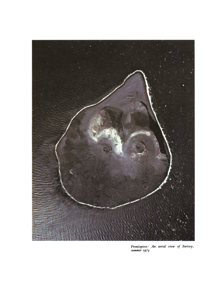
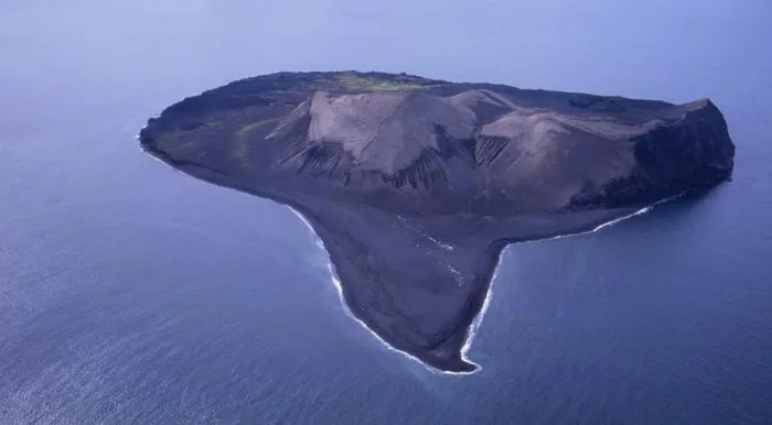
The island of Surtsey is doomed. The only question is how long the island will remain. Surtsey was once 2.5 square kilometers, but as of 2002 it was 1.4 square kilometers. The initial high erosion rate was mainly from loose material being washed away, and now that there is only harder material remaining the rate of erosion has diminished. Calculating the life expectancy has yielded different results, but it is clear that somewhere between 100 to 1 000 years from now the island will disappear under the surface. Most likely the island will fairly rapidly diminish until only a hardened stack of solidified basalt remains above the surface, and ultimately that will crumble and fall down into the ocean. Before that happens new islands will most likely have happened, most probably to the southwest of Surtsey as the EVZ spreads down in southwesterly direction where it will at some time merge directly with the Mid Atlantic Rift.
Biological and human impact on Surtsey
The island was quickly declared a living laboratory for biological settlement on newly formed land. Surtsey was therefore declared a natural reserve in 1965 and it was declared that only a select group of scientists would be able to land on the island. In 2008 Surtsey was declared a UNESCO World Heritage Site, further increasing its protection.
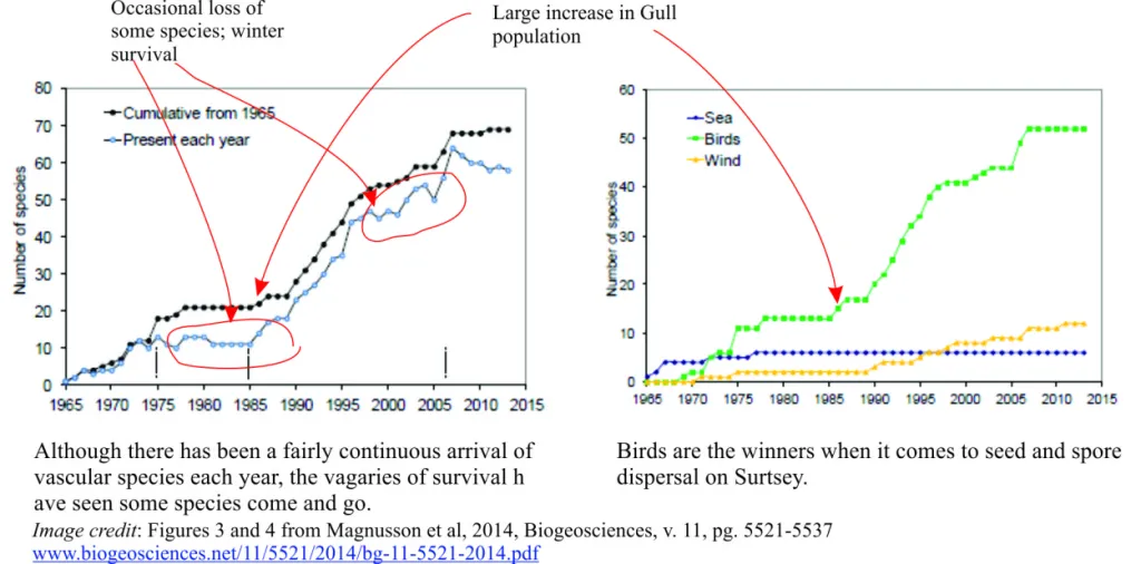
The first plant was reported in the spring of 1965, a sea rocket (Cakile arctica). It was followed by the sea sandwort (Hokenya peploides), sea lyme grass (Leymus arenarius) and oyster plant (Martensia maritima). The expectation was that lichens would be the first invaders, paving the way for moss, in turn followed by grass. These sequence is found in lava fields in Iceland. However, on Surtsey bacteria, moulds, algae and plants came first, and moss did not begin to grow until three years later. Lichen only followed 8 years after the eruption. The reason was that Surtsey quickly acquired sandy beaches, where the waves brought in organic material: seaweed and the remains of various organisms. Life started on the top end of these beaches rather than on the cooling lava, likely seeded from Heimaey, 18-km away, or the south coast of Iceland at 32 km. Away from the beach, by 1975 moss had become the dominant life form. Birds started nesting in 1970, with a black guillemot (Cepphus grylle) a fulmar (Fulmarus glacialis). A variety of sea birds nested, such as puffins, followed in 1996 by snow buntings.
In 2008 69 separate species of plant life had found its way to the island and there are also birds nesting on the island and the seals have inevitably found the northern gravel spit and annexed it as their breading ground and that in turn attracted a flock of Orcas feeding on the seals. In 2009 the island had 15 species of nesting birds on the island when a Golden Plover nested there. 53 different types of mosses were reported, 71 types of lichens and 89 bird species. About a quarter of the plant species are sporadic, meaning that the populations are too small to be self-supporting.
Humans could as usual not stay away from the island. During a raid on the island performed by a bunch of boys potatoes where planted. They were quickly dug up before they could cause any damage. In 2009 a scientist suffered a bout of bowel movement and defecated in a non-approved manner resulting in a tomato plant that later was destroyed. There is also a hut on the island housing the scientists during their visits to the island.
There is no permanent monitoring equipment on the island. The nearest equipment is a combined SIL/GPS-station on Heimaey. Even though the situation is better now than during the Surtsey eruption the area is generally under-monitored by Icelandic standards and could well do with a commemorative upgrade since there will be further eruptions in the Vestmannaeyar Volcanic Zone.
Source: volcanocafe.org