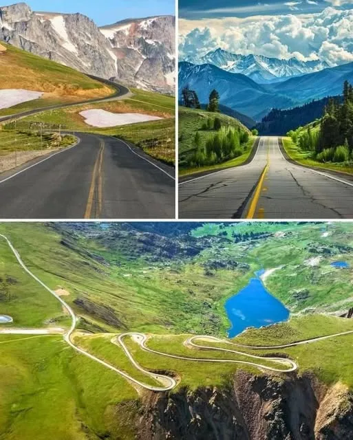
Tucked away in the northern Rockies, the Beartooth Highway (U.S. Highway 212) is a bucket-list road trip often hailed as one of America’s most breathtaking drives. Spanning roughly 68 miles from Red Lodge, Montana, to the Northeast Entrance of Yellowstone National Park near Cooke City, this route is a journey through towering peaks, alpine tundra, and glacial lakes—a true highway to the sky.
Why the Beartooth Highway Stands Out
-
Alpine Wonderland: Climbing to 10,947 feet at Beartooth Pass, the highway takes you above the tree line into a rare alpine tundra, dotted with wildflowers and snowfields even in summer.
-
Epic Views: Hairpin switchbacks reveal jaw-dropping vistas of glaciated peaks, deep valleys, and sprawling plateaus that feel like another world.
-
Wildlife Galore: Keep an eye out for mountain goats, marmots, elk, and, if you’re lucky (and cautious), grizzly bears.
-
Seasonal Adventure: Open typically from Memorial Day to mid-October, the road can close due to snow even in early summer, making timing key.
The Route at a Glance
-
Length: ~68 miles (109 km)
-
Route: Red Lodge, Montana, to Cooke City, Montana, near Yellowstone National Park
-
Elevation: Peaks at Beartooth Pass (10,947 feet)
-
Driving Time: About 2–3 hours without stops, but you’ll want to linger for photos and exploration.
Must-See Stops Along the Way
-
Red Lodge, MT: This charming mountain town is the perfect starting point, with cozy restaurants, local shops, and outfitters for hiking or skiing gear.
-
Beartooth Pass: The highway’s crown jewel, offering 360-degree views of the rugged Absaroka-Beartooth Wilderness. On a clear day, you can see for miles.
-
Top of the World Store: A quirky, remote outpost at 9,400 feet, offering snacks, souvenirs, and (sometimes) gas. It’s a welcome break in the wild.
-
Cooke City, MT: A rustic gem near Yellowstone’s Northeast Entrance, perfect for grabbing a meal or soaking in the frontier vibe.
-
Yellowstone National Park: The highway leads straight to the park’s Lamar Valley, a hotspot for wildlife like bison and wolves.
The Beartooth Name
The highway takes its name from Beartooth Peak, a jagged summit resembling a bear’s tooth. The surrounding Absaroka-Beartooth Wilderness is a haven for backcountry enthusiasts, with over 900,000 acres of pristine peaks, lakes, and trails.
Tips for an Unforgettable Drive
-
Take It Slow: The winding roads and stunning views demand a leisurely pace. Use pullouts to let faster traffic pass and soak in the scenery.
-
Dress in Layers: Summer temperatures at the summit can drop below freezing, and wind is common at higher elevations.
-
Check the Weather: Snow can linger into July or arrive early in September, so check road conditions before you go.
-
Fuel Up: Gas stations are scarce between Red Lodge and Cooke City, so fill up beforehand.
-
Bring a Camera: The dramatic landscapes and wildlife make this a photographer’s paradise.
Plan Your Journey
The Beartooth Highway isn’t just a drive—it’s an experience that captures the raw beauty of the American West. Whether you’re chasing adventure, wildlife, or simply unforgettable views, this road delivers. Plan your trip between late spring and early fall, pack for unpredictable weather, and prepare to be awed by one of the most scenic drives in the world.
Have you driven the Beartooth Highway or added it to your travel list? Share your thoughts or tips below!