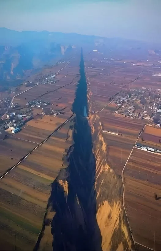
Pinglu Rift Valley: Scratches of the Earth’s Tectonic Dance
Nestled within the mountainous expanse of Pinglu in north-central China, the Pinglu Rift Valley emerges as a striking geological wonder, stretching across a region covering approximately 400,000 square kilometers. Formed by movements deep within the Earth’s crust, this valley spans about 10 kilometers and began taking shape around 10 million years ago due to powerful tectonic forces. Positioned along the boundary where the Eurasian Plateau and the northern China bloc are gradually separating, the Pinglu Rift Valley stands as a vivid testament to the Earth’s dynamic evolution. As of July 2025, it continues to captivate geologists and adventurers alike with its dramatic landscape and geological significance.
Geological Formation
The Pinglu Rift Valley’s origins trace back approximately 10 million years, a period marked by tectonic activity as the Eurasian Plate and the North China Block began to diverge. This process, part of the broader Shanxi Rift System, involves extensional tectonics where the Earth’s crust stretches and fractures, creating a lowland depression. The valley’s formation is linked to the Sanmenxia Basin within the Weihe Graben, a region shaped by back-arc extension from Pacific Plate subduction and the Indian Plate’s collision with Eurasia. The valley cuts through the Loess Plateau’s soft, windblown loess sediment, contributing to its steep cliffs and depths reaching around 100 meters at their most profound points.
While the narrative of a clear rift valley formed solely by plate separation is widely accepted, some skepticism arises. The region’s flat terrain and linear channels, as noted in some observations, raise questions about whether all features are purely tectonic or if erosion and human activity might have played a role. The possibility of transform faults or artificial modifications complicates the story, suggesting the valley’s “scratches” might reflect a blend of natural and cultural influences over time.
Landscape and Features
Stretching 10 kilometers in length and 1-2 kilometers in width, the Pinglu Rift Valley showcases nature’s artistry with steep cliffs sculpted from loess, a fertile yet erodible sediment. At its deepest, the valley plunges to about 100 meters, offering a dramatic contrast to the surrounding plateau. The loess, deposited by ancient winds, tells a tale of shifting climates and landscapes, while the valley’s rugged terrain supports a rich tapestry of rare plants and animals, enhancing its ecological value.
The valley’s formation process—tectonic stretching followed by erosion—has created a unique topography, with some areas resembling narrow chasms rather than a classic rift valley’s wide depression. This ambiguity fuels ongoing debate about its classification, with some suggesting it might be a hybrid feature shaped by both geological forces and water flow.
Cultural and Scientific Significance
The Pinglu Rift Valley lies within the Loess Plateau, a region with a 5,000-year history of human habitation, where ancient civilizations carved settlements into the loess and developed irrigation systems. This geological marvel not only reflects Earth’s tectonic past but also intersects with human history, offering a lens into how early societies adapted to such landscapes. Today, it serves as a living laboratory for geologists studying continental rift formation, providing insights into plate movements and the evolution of the Earth’s crust.
The valley’s proximity to fault lines raises questions about seismic risks, with some speculating it could signal future activity. Its preservation as a natural heritage site underscores the need to balance scientific study with ecological and cultural protection.
Preservation and Exploration
As of July 2025, the Pinglu Rift Valley remains a relatively underexplored site, with limited infrastructure due to its remote location in Shanxi Province. Efforts to protect its loess cliffs from erosion and human impact are ongoing, though challenges like rainfall-induced landslides persist. The valley beckons adventurers with its stark beauty, but access is primarily via guided tours or research expeditions, with plans to develop educational trails in the works.
Posts found on X highlight its awe-inspiring scale, with users describing it as a “geological scar” and marveling at its “hidden depths,” though some caution about its rugged terrain. Conservation efforts focus on monitoring tectonic stability and mitigating erosion, ensuring this natural wonder endures.
Future Prospects
The Pinglu Rift Valley’s ongoing tectonic activity suggests it may continue to evolve, potentially widening or deepening with future movements. Geologists are employing GPS and satellite imagery to track changes, while climate change’s impact on loess erosion remains a concern. Future research could clarify its tectonic versus erosional origins, deepening our understanding of China’s geological narrative.